RUTM52 NTRIP
The information in this page is updated in accordance with firmware version RUTM_R_00.07.10.3.
Summary
NTRIP - Networked Transport of RTCM via Internet Protocol. NTRIP stands for an application-level protocol for streaming Global Navigation Satellite System (GNSS) data over the Internet. It is a generic, stateless protocol based on the Hypertext Transfer Protocol HTTP. NTRIP is an RTCM standard designed for disseminating differential correction data (e.g in the RTCM-104 format) or other kinds of GNSS streaming data to stationary or mobile users over the Internet, allowing simultaneous PC, Laptop, PDA, or receiver connections to a broadcasting host. NTRIP is implemented in three system software components: NtripClients, NtripServers and NtripCasters. The NtripCaster is the actual HTTP server program whereas NtripClient and NtripServer are acting as HTTP clients.
Our device acts as NTRIP client and via serial connected end device as RTK receiver. Server to which device application connects acts as NTRIP caster. RTK is short for real time kinematics. A GPS receiver capable of RTK takes in the normal GPS signals from the Global Navigation Satellite Systems along with a correction stream (provided from our router serial device) and achieve up to 1cm positional accuracy.
This manual page provides an overview of NTRIP functionality in RUTM52 devices.
Note: NTRIP is additional software that can be installed from the System → Package Manager page.
NTRIP status
NTRIP client
Networked Transport of RTCM via Internet Protocol (NTRIP) is a protocol for streaming differential GPS (DGPS) data over the Internet in accordance with specification published by RTCM.
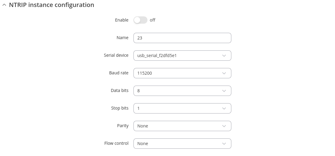
Note: NTRIP supports up to 20 configurations per device.
| Field | Value | Description |
|---|---|---|
| Enable | off | on; default: off | Enables NTRIP service. |
| Name | string; default: empty | Custom name of serial device. |
| Device | ; default: | Specifies which serial port will be used for serial communication. |
| Data bits | 5 | 6 | 7 | 8; default: 8 | How many bits will be used for character. |
| Stop bits | 1 | 2; default: 1 | How many stop bits will be used to detect the end of character. |
| Parity | Even | Odd | Mark | Space | None; default: None | What kind of parity bit to use for error detection. |
| Flow control | RTS/CTS | Xon/Xoff | None; default: None | What kind of characters to use for flow control. |
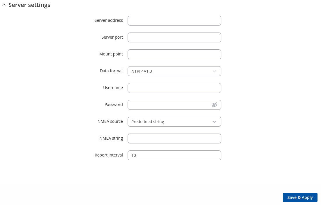
| Field | Value | Description |
|---|---|---|
| Server address | ip; default: none | IP address of an NTRIP server. |
| Server port | integer [0..65535]; default: none | TCP/UDP port used for NTRIP communication. |
| Mount point | filepath | string; default: none | NTRIP mount point. |
| Data format | NTRIP V2.0 TCP/IP | NTRIP V2.0 RSTP/RTP | NTRIP V1.0 | Automatic detection | NTRIP V2.0 UDP; default: NTRIP V1.0 | Version of NTRIP protocol. |
| Username | string; default: none | Username for authentication to an NTRIP server. |
| Password | string; default: none | Password for authentication to an NTRIP server. |
| NMEA source | Predefined string | Predefined coordinates | Serial device | Router GPS device; default: Predefined string | Optional NMEA string that will be used as the default value when initiating the connection to the NTRIP server (this value is only sent to the server if there is no NMEA from router's GPS device). |
| NMEA string | string; default: none | GPGGA NMEA string to be used to initiate communication with the server. Note: GGA string validation now allows all manufacturer codes (not only GPGGA). |
| Lattitude | string; default: none | Lattitude to be used to generate NMEA string for initiating communication with the server. |
| Longitude | string; default: none | Longitude to be used to generate NMEA string for initiating communication with the server. |
| Report interval | integer[1..86400]; default: 10 | Allows to obtain default NMEA string from the router's GPS device. Only works if GPS service is enabled and location fix is obtained at the time of NTRIP service start. |


