Template:Rms manual management device submenu gps location: Difference between revisions
(Created page with "===Setting Location=== RMS has 3 ways to determine device's location: <li><strong>Manual location selection</strong></li> <li><strong>Using device GPS information</strong> -...") |
|||
| (3 intermediate revisions by one other user not shown) | |||
| Line 1: | Line 1: | ||
== | ==Summary== | ||
RMS has 3 ways to determine device's location: | RMS has 3 ways to determine device's location: | ||
| Line 6: | Line 6: | ||
<li><strong>Using Cell tower information</strong> - used when location is not set manually and there is no GPS information from device.</li> | <li><strong>Using Cell tower information</strong> - used when location is not set manually and there is no GPS information from device.</li> | ||
===Manual sellection=== | |||
---- | ---- | ||
| Line 17: | Line 17: | ||
[[File:Rms manual device submenu gps location 02.png|class=tlt-border|border]] | [[File:Rms manual device submenu gps location 02.png|class=tlt-border|border]] | ||
===Using Device GPS=== | |||
---- | ---- | ||
If device has GPS functionality, device's location can be retrieved from device itself. For that "GPS monitoring" setting in RMS must be enabled. Guidance how to do that can be found [[ | If device has GPS functionality, device's location can be retrieved from device itself. For that "GPS monitoring" setting in RMS must be enabled. Guidance how to do that can be found [[RMS_Management_menu#Set_update_period | here]]. | ||
===Using Cell tower information=== | |||
---- | ---- | ||
RMS can try to determine approximate device's location using cell tower information. This is done one time a day, at 00:00 UTC+0 time. Location is determined using the following cell tower [https://opencellid.org/#zoom=16&lat=37.77889&lon=-122.41942 database] | RMS can try to determine approximate device's location using cell tower information. This is done one time a day, at 00:00 UTC+0 time. Location is determined using the following cell tower [https://opencellid.org/#zoom=16&lat=37.77889&lon=-122.41942 database] | ||
==Location Priority== | |||
Each method has different priority: | Each method has different priority: | ||
Latest revision as of 06:24, 28 May 2024
Summary
RMS has 3 ways to determine device's location:
Manual sellection
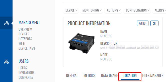
Device position can be set manually from RMS. That can be done by opening device's details, selecting "Location" tab
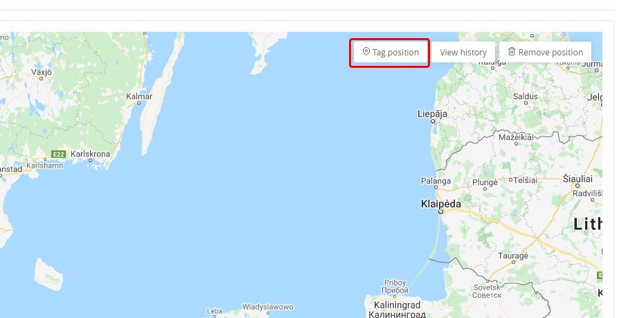
World map will appear, you can zoom in to preferred location by scrolling mouse wheel then press "Tag position" button select location on map and click Save
Using Device GPS
If device has GPS functionality, device's location can be retrieved from device itself. For that "GPS monitoring" setting in RMS must be enabled. Guidance how to do that can be found here.
Using Cell tower information
RMS can try to determine approximate device's location using cell tower information. This is done one time a day, at 00:00 UTC+0 time. Location is determined using the following cell tower database
Location Priority
Each method has different priority:
Highest priority - Manually set location. If device location is manually set, it will be shown at all time, regardless of actual device's GPS coordinates
Second highest priority - Device's GPS information. If "GPS monitoring" is enabled for device from RMS side and its location is not manually set, RMS will always try to show GPS information retrieved from device. If no GPS information is received from device (e.g. device does not have GPS functionality or does not have GPS antenna connected), no location information will be displayed.
Lowest priority - Approximate location based on cell towers. It is only shown when device location is not manually set and when device's "GPS monitoring" is disabled.


